Backpacking beyond the mountains
/On Ireland’s western seaboard is a secret coast of giant cliffs, dramatic tarns, and one gloriously isolated beach. Lenny Antonelli and two friends wild camp in the ‘Back of Beyond’.
The Great Outdoors, November 2014
You have no reason to know about Annagh. Frankly I’m even a bit reluctant to tell you. Annagh is the kind of place that makes a travel writer go ‘oh, there’s a story here’, then think twice and wonder if he should keep it all to himself. Annagh is a remote beach on Ireland’s largest island, Achill, a place of mountainous cliffs and screaming surf that is fringed by gusty beaches and capped with boggy hills.
You’ll find Annagh on a hidden coast that culminates with the highest cliffs in the geographical British Isles. But more than likely you won’t find it. You can bag Achill’s peaks and hike its trails and not see it. You can read the brochures and guidebooks and be no wiser. Far from any road, this coast was described by the naturalist Thomas A Barry as a land “beyond the mountains”; he called it “the back of beyond”.
Sitting in an Achill pub, an old islander once told me even he’d never been to Annagh. I had hiked there before, but like any compulsive backpacker, I had to come back and camp.
I left Galway the day before the trek with Will and John, two pals I roped in. But we stopped in the coastal town of Westport, and made the classic mistake of having one too many ales the night before a big hike.
The next day we crossed the bridge at Achill Sound to reach the island under blue-bright skies. But we looked at the 671-metre cone of Slievemore, which we had planned on climbing, and found ourselves wussing out. So we took a shortcut and drove to the other side of the mountain. Climbing Slievemore wasn’t essential for reaching Annagh, our hungover heads reasoned, and what was ahead of us tomorrow would be enough.
We loaded our packs and set out under Achill’s eeriest tourist attraction: the 100 or so cottages of a deserted village, strung out under the mountain. We followed a track to an old quarry, then climbed into the low hills that guard the Back of Beyond. Soon John shouted “lizard!”. But I could see no lizard, just a strange worm writhing in the grass. “It shed its tail,” John said. So we gawped at the disembodied tail, which continued to twist and shake long after the lizard left.
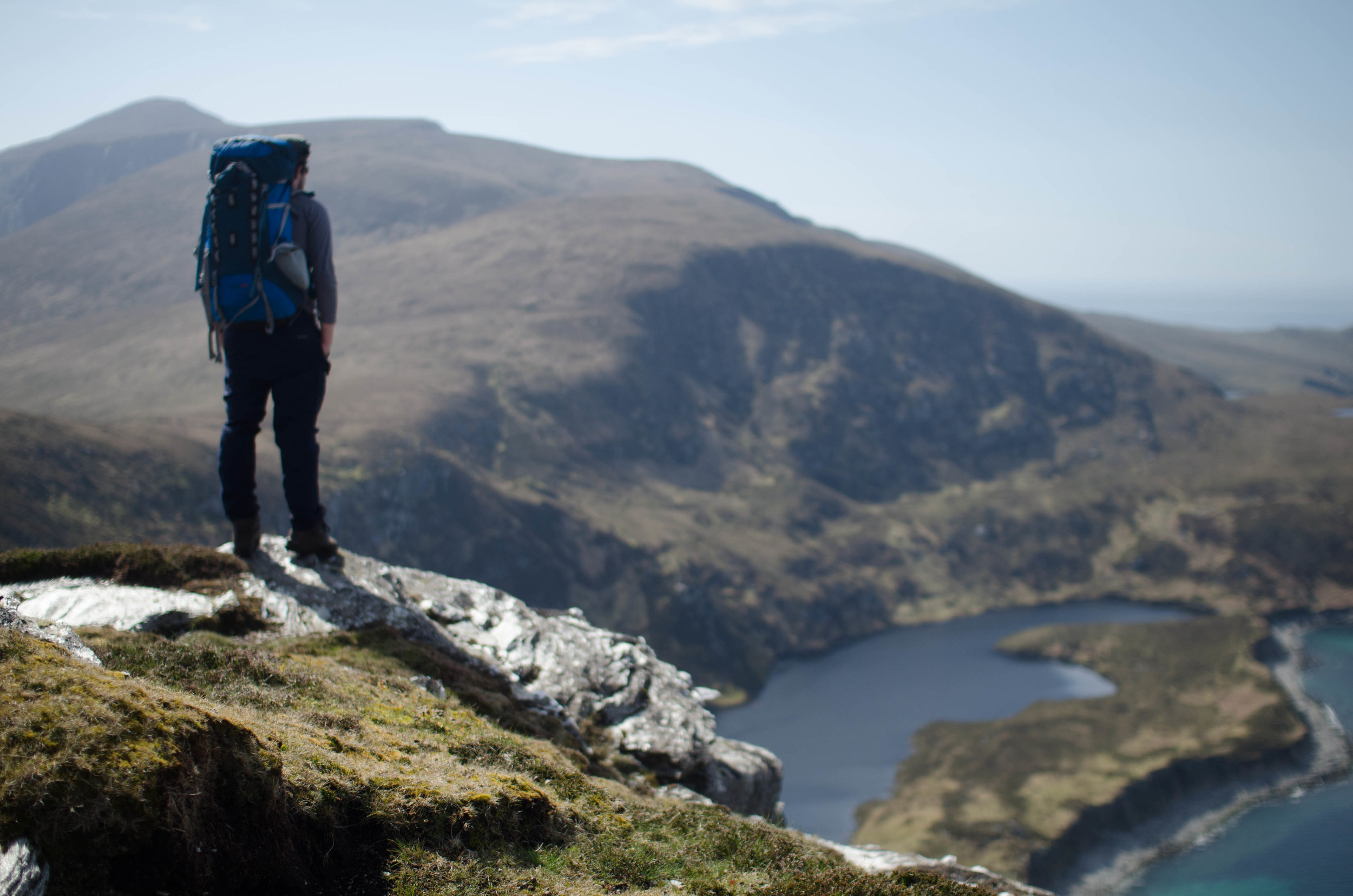
We rested by a ruined lookout tower, then dropped into a saddle and started up the next hill. The day was hot and clammy, and the damp slopes were a bore. All that interested me was still far ahead of us. From the next hill we looked out on the Inishkea Islands, abandoned in the 1930s after a storm drowned ten of their fishermen. We descended and savoured the breeze, emerging above a rocky outcrop, and, far below us, it appeared: the flaxen strand at Annagh, protected by mountains, right under Lough Nakeeroge East. Everything shook with green and blue.
There is no easy way down to Annagh; all routes are steep. But sheltered on three sides, this valley is sometimes so calm that its silence will shock you. Before the land was bare of flowers but here we found primrose, violet and wood sorrel. Hell, there were even a few trees.
We don’t make enough time for places like Annagh, low places we march past in our rush to bag peaks. We organise summits into lists and devour guidebooks that show us how to reach the high points. But what about the low places? We’ve built roads through most deep valleys and concreted over low-lying coasts. So let’s celebrate a new outdoor pursuit: trough-bagging. Because when you find somewhere like Annagh, low in altitude but entirely separate from modern civilisation, you have a found a wild place.
We made camp by the lake, then went down to the beach to swim. After, we built a small campfire. Responsible backpackers don’t usually make fires, and with good reason. They scorch the earth and risk getting out of control. Plus there’s not much deadwood in the Irish hills. But a good fire makes a camp, so if you can make one safely and leave no trace, why not? We burned some timber we found, along with loose dead heather, on big slabs of rock to protect the earth. By 1am the sky was purple and flecked with stars, as if someone shook a white paintbrush against it.
It was around then I remembered Annagh is haunted. Its ghost stories, recalled in local historian Theresa McDonald’s book Achill Island, usually involve visitors meeting a terrible fate of some sort. Others mention riderless horses and the “unnerving presence of a tall thin man”; girls sleeping in a hut whose dog was thrown on them by an unknown entity; and the man who returned home to find his wife climbing the hill above their cottage with her mattress, terrified by something she saw, determined to leave forever. Theresa advises that, “even today, few people would volunteer to stay overnight in Annagh.” I would advise that you have a drop of good whiskey before bed.
In the morning I tidied camp, collected drinking water and made coffee while Will and John slept in. Then I tidied more and cooked breakfast while they slept in some more. After they woke we swam again, then broke camp. We went west, past the ruined stone cottages of Annagh ‘booley’ village. Families once brought livestock to summer pasture in remote settlements like this. I tried to quicken our pace, anxious for what was ahead, as we hiked a narrow strip of bog between mountains and ocean.
Seven miles out Black Rock emerged from the sea clouds, like a rotting incisor breaking through the waves, a lighthouse stuck to its side. The last keepers left in 1974. It reminded me of the mythical island Hy Brasil, which in Irish legend appears out of the mist off the west coast every seven years. The land began to slope upwards, and I knew we were close. Hunched under heavy packs and slowed by the heat, we climbed. The sea breeze picked up as we neared the edge. Then we stepped out on the sheer precipices of Saddle Head.
But these cliffs did not interest us. What mattered was in front of us: the six-hundred-metre-plus cliffs of Croaghaun, expanding for two kilometres across the range of our vision, so vast that whenever I see them, my first reaction is often to laugh out loud. Thank god it’s so bloody hard to get here or the place would be buried under a car park and interpretative centre. Croaghaun, realm of the peregrine falcon, isn’t so much a cliff as a mountain that falls from its 688-metre summit into the sea, and looks like it might carry on down forever under the waves.
We hiked up through a scree field, and soon Lough Bunafreva West appeared. This place would be impossible to imagine if it didn’t exist: a tarn inserted half-way up these almighty cliffs. The Irish naturalist Robert Lloyd Praeger said this lake was, “so lonely and sterile and primeval that one might expect to see the piast or other Irish water-monster rising from the inky depths”. To me it looked like the piast bit a hole in the cliff to make a lake-home for herself in the most godforsaken place imaginable.
I was out of drinking water, so with no streams around I collected some from the tarn, and it was cold and clear. Eager to gain altitude, we scrambled up the steep corrie wall. Half way up, with little rock for grip, I stopped for breath. Looking down into the tarn, I knew we’d picked the steepest and stupidest route possible. But the hard climbing was done. On the plateau above we went west to Croaghaun’s summit, over peat hags, heath slopes and exposed quartzite.
Then something bizarre happened. A man and woman approached us who, on this most exposed mountain, had no supplies and told us they had come up the steep face behind the nearby reservoir. This always looked more like a rock climb than a hill walk to me. I suggested a safer route down; they ignored me and walked off in the opposite direction. We kept on towards the summit, hand-railing the cliff edge.
Just below the summit, Will shouted: “Goats!”. But there were no goats. “They went right over the edge,” he said. I wondered if they had fallen to a most vertical death, but later read that Thomas Barry looked through binoculars and spotted wild goats on tiny shores at the bottom of these cliffs, nearly seven hundred metres down.
The summit was swarming with midges, so we didn’t rest long. Through deep heather we descended the south-face of Croaghaun to Keem, a postcard-blue bay sheltered by steep hills. This marked our return to civilisation. Day-trippers were relaxing on the grass above the beach. Caked in my own sweat and smelling more dead than alive, I went down to the beach to swim in the deep cold water.
After my dip I got out, dried off, and turned around. Then, just a few metres from where I swam, a bottlenose dolphin and her calf surfaced. Then a seal popped up, and when I looked around, there were dolphins all across the bay. They lingered for a few minutes and then, perhaps realising they’d hit a dead end, turned around and left the bay. If they were trying to find the Back of Beyond, I wasn’t going to offer directions.
Where are the tallest cliffs?
Donegal’s Slieve League is often called Ireland’s highest cliff, probably because it is more accessible than 688 metre Croaghaun. But at 595 metres, it’s a fair bit shorter. The UK’s highest cliff is 430 metres Conachair on St Kilda, while Devon’s Great Hangman at 244 metres is the tallest in England or Wales. In Europe, the highest sea cliff is often said to be Norway’s mighty Hornelen at 860 metres, though 754 metres Cape Enniberg on the Faroe Islands is more vertical. Inland, Norway’s Troll Wall is the tallest vertical rock face in Europe at 1,100 metres.
But what is a cliff anyway? Some of the world’s great mountains have rock faces that are near-vertical enough to be considered cliffs. For example, Nanga Parbat's Rupal Flank rises 4,600 metres from its base. Others says the world’s highest near-vertical drop is the eastern face of Great Trango tower in Pakistan at 1,340 metres. Meanwhile Mount Thor on Canada’s Baffin Island, at 1,250 metres is regarded as the world’s tallest totally vertical drop.
But the tallest known cliff isn’t even on Earth. Verona Rupes, a massive scarp on Miranda, a moon of Uranus, is up to 20 kilometres high. We eagerly await news of a first ascent.
Achill: How to do it
Achill Island, Ireland’s largest island, is connected to the mainland by bridge at Achill Sound, Co Mayo. You can fly from various UK airports to Ireland West Airport Knock,
Co Mayo. The nearby towns of Westport and Castlebar are serviced by bus (buseireann.ie) and trains (irishrail.ie) from Dublin. If driving from Westport take the N59 to Achill; from Castlebar taking the R311 to join the N59 at Newport.
The map you will need is Ordnance Survey Ireland Discovery Series Sheet 30. The coastline known as the Back of Beyond runs from Annagh Strand, north of Dooagh, west to Saddle Head. Achill is a mecca for outdoor pursuits, with two dramatic mountains (688m Croaghaun and 671m Slievemore), a variety of lower-level hikes plus surfing, kitesurfing, kayaking and more. See irishtrails.ie and achilltourism.com for local hikes, and mountainviews.ie for detailed info on Irish mountains.
This entire trip enters very remote and mountainous terrain. The descent to Annagh/Lough Nakeeroge East, and the ascent to Croaghaun’s summit plateau from near Saddle Head, are both steep, tricky routes that demand good navigation and route-finding skills. For a more gradual alternative to our steep ascent of the corrie wall at L Bunafreva West, there is a spur (around F 576 080) to the north-east of the lake, though this route has steep sections too.
If you’re looking for a great local guide, whose great grandfather worked as a salmon fisherman from Annagh, contact Gerard Mangan at achillislehouse.com or Tel: +353-98-43355.